We are happy to share the news that our Policy Brief is ready for download here:
અમને એ સમાચાર શેર કરવામાં આનંદ થાય છે કે અમારી પોલિસી બ્રીફ અહીં ડાઉનલોડ કરવા માટે તૈયાર છે:
ENGLISH: NTU, GIDM, CHC CRDF & Hunnarshala Foundation. 2022. A framework for earthquake assessment, re-construction and risk mitigation of buildings in historical settlements of Gujarat using advanced recording technologies. Edited by: B. Devilat, F. Lanuza, R. Kanji, J. Desai, M. Mane, Z. Pithawalla, A. Singh & M. Acharya. Policy Brief. Nottingham Trent University: UK. DOI: [10.17631/rd-2022-0006-dfram]
HINDI: NTU, GIDM, CHC CRDF & Hunnarshala Foundation । २०२३ । ए फ्रेमवर्क फॉर अर्थकवेक एसेसमेन्ट, रि-कंस्ट्रकशन एन्ड रिस्क मिटिगेशन ऑफ़ बिल्डिंग्स इन हिस्टोरिक सेटलमेन्टस ऑफ़ गुजरात युसिंग एडवान्स्ड रिकॉर्डिंग टेकनोलोजीस । पोलिसी ब्रीफ । नोटिंघम ट्रेंट यूनिवर्सिटी: यु.के । पर उपलब्ध । संपादन: डेविलेट, बी., लानुज़ा, एफ, कांजी आर., देसाई, जे., माने, एम., पीठावाला झि., सिंघ आ., आचार्य, एम. DOI: [10.17631/rd-2023-0004-dfram]
GUJARATI: NTU, GIDM, CHC CRDF અને હુન્નરશાળા ફાઉન્ડેશન. 2023. અદ્યતન રેકોર્ડિંગ ટેક્નોલોજીનો ઉપયોગ કરીને ગુજરાતની ઐતિહાસિક વસાહતોમાં ધરતીકંપની આકારણી, પુનઃનિર્માણ અને ઇમારતોનું જોખમ ઘટાડવા માટેનું માળખું. સંપાદિત: બી. દેવિલત, એફ. લનુઝા, આર. કાનજી, જે. દેસાઈ, એમ. માને, ઝેડ. પીઠાવાલા, એ. સિંહ અને એમ. આચાર્ય.નીતિ સંક્ષિપ્ત. નોટિંગહામ ટ્રેન્ટ યુનિવર્સિટી: યુકે. પરથી ઉપલબ્ધ DOI: [10.17631/rd-2023-0005-dfram]
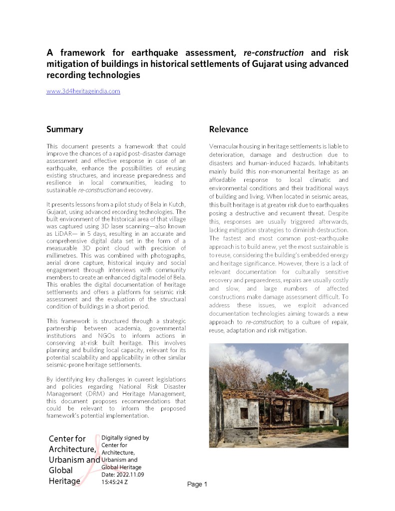
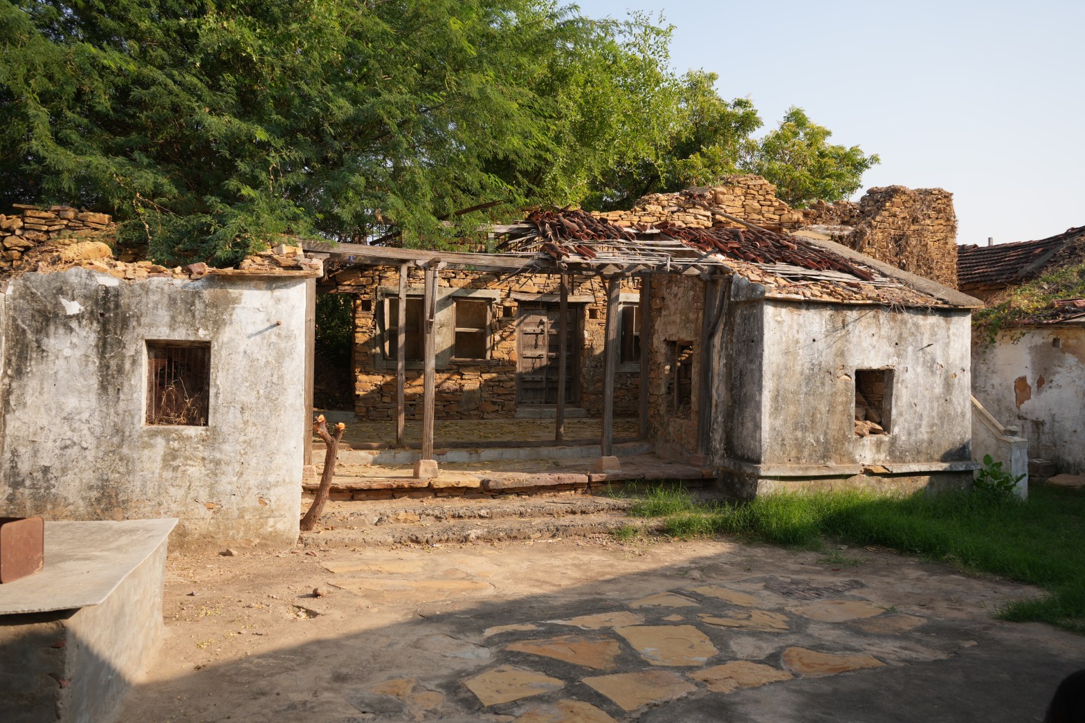
This document presents a framework that could improve the chances of a rapid post-disaster damage assessment and effective response in case of an earthquake, enhance the possibilities of reusing existing structures, and increase preparedness and resilience in local communities, leading to sustainable re-construction and recovery. It presents lessons from a pilot study of Bela in Kutch, Gujarat, using advanced recording technologies. The built environment of the historical area of that village was captured using 3D laser scanning—also known as LiDAR— in 5 days, resulting in an accurate and comprehensive digital data set in the form of a measurable 3D point cloud with precision of millimetres. This was combined with photographs, aerial drone capture, historical inquiry and social engagement through interviews with community members to create an enhanced digital model of Bela. This enables the digital documentation of heritage settlements and offers a platform for seismic risk assessment and the evaluation of the structural condition of buildings in a short period. This framework is structured through a strategic partnership between academia, governmental institutions and NGOs to inform actions in conserving at-risk built heritage. This involves planning and building local capacity, relevant to its potential scalability and applicability in other similar seismic-prone heritage settlements. By identifying key challenges in current legislation and policies regarding National Risk Disaster Management (DRM) and Heritage Management, this document proposes recommendations that could be relevant to inform the proposed framework’s potential implementation.
આ દસ્તાવેજ એક માળખું રજૂ કરે છે જે આપત્તિ પછીના નુકસાનની ઝડપી આકારણી અને ધરતીકંપના કિસ્સામાં અસરકારક પ્રતિભાવની શક્યતાઓને સુધારી શકે છે, હાલના માળખાની પુનઃઉપયોગની શક્યતાઓને વધારી શકે છે તથા સ્થાનિક સમુદાયોમાં સજ્જતા અને સ્થિતિસ્થાપકતામાં વધારો કરી શકે છે, જે ટકાઉ પુનઃનિર્માણ તરફ દોરે છે. અદ્યતન રેકોર્ડીંગ ટેકનોલોજીનો ઉપયોગ કરીને તે ગુજરાતના કચ્છમાં બેલાના પ્રાયોગિક અભ્યાસમાંથી પાઠ રજૂ કરે છે. તે ગામના ઐતિહાસિક વિસ્તારના બિલ્ટ એન્વાયર્નમેન્ટને 3D લેસર સ્કેનીંગ-જેને LiDAR તરીકે પણ ઓળખવામાં આવે છે, તેનો ઉપયોગ કરીને ૫ દિવસમાં કેપ્ચર કરવામાં આવ્યું હતું, જેના પરિણામે મિલીમીટરની ચોકસાઇ સાથે માપી શકાય તેવા 3D પોઇન્ટ ક્લાઉડના રૂપમાં સચોટ અને વ્યાપક ડિજિટલ ડેટા સેટ તૈયાર કરવામાં આવ્યો હતો. બેલાનું ઉન્નત ડિજિટલ મોડલ બનાવવા માટે ફોટોગ્રાફ્સ, એરિયલ ડ્રોન કેપ્ચર, ઐતિહાસિક પૂછપરછ અનેસમુદાયના સભ્યો સાથે મુલાકાતો દ્વારા સામાજિક જોડણો સાથે જોડવામાં આવ્યું હતું. આ હેરિટેજ વસાહતોના ડિજિટલ દસ્તાવેજીકરણને સક્ષમ કરે છે તથા સિસ્મિક જોખમના મૂલ્યાંકન અને ટૂંકા ગાળામાં ઇમારતોની માળખાકીય સ્થિતિના મૂલ્યાંકન માટે પ્લેટફોર્મ પ્રદાન કરે છે. આ માળખું શૈક્ષણિક સંસ્થાઓ, સરકારી સંસ્થાઓ અને એનજીઓ વચ્ચે વ્યૂહાત્મક ભાગીદારી દ્વારા સંરચિત કરવામાં આવ્યું છે જેથી જોખમમાં આવેલા વારસાના સંરક્ષણમાં યોગ્ય પગલાં લઇ શકાય. આમાં સ્થાનિક ક્ષમતાનું આયોજન અને નિર્માણનો સમાવેશ થાય છે, જે તેની સંભવિત માપનીયતા અને અન્ય સમાન સિસ્મિક-પ્રોન હેરિટેજ વસાહતોમાં લાગુ પાડવામાં આવે છે. નેશનલ રિસ્ક ડિઝાસ્ટર મેનેજમેન્ટ (DRM) અને હેરિટેજ મેનેજમેન્ટને લગતા વર્તમાન કાયદાઓ અને નીતિઓમાં મુખ્ય પડકારોને ઓળખીને, આ દસ્તાવેજ ભલામણો સૂચવે છે જે સૂચિત માળખાના સંભવિત અમલીકરણની માહિતી આપવા માટે ઉપયોગી થઇ શકે છે.
